The ST_Overlaps() function

The ST_Overlaps() function returns t (TRUE) if the intersection of two ST_Geometry objects results in an ST_Geometry object of the same dimension but not equal to either source object. Otherwise, it returns f (FALSE).

Syntax

ST_Overlaps(g1 ST_Geometry, g2 ST_Geometry)

Usage

The following figure shows various geometric objects that overlap.
Figure 1: Overlapping geometries

This graphic shows various geometric objects that overlap.

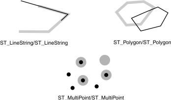
The results of the spatial relationship of the ST_Operlaps() function can be understood or verified by comparing the results with a pattern matrix that represents the acceptable values for the DE-9IM. The ST_Operlaps() function returns TRUE if the intersection of the objects results in an object of the same dimension but not equal to either source object.

This pattern matrix applies to ST_Polygon and ST_Polygon; ST_MultiPoint and ST_MultiPoint; and ST_MultiPolygon and ST_MultiPolygon overlaps. For these combinations, the ST_Overlaps() function returns TRUE if the interior of both geometries intersects the other's interior and exterior.
Table 1. Pattern matrix for the ST_Overlaps() function

The table is a matrix. The top row and first column identify the geometry.

Interior (b) Boundary (b) Exterior (b)
Interior (a) T * T
Boundary (a) * * *
Exterior (a) T * *
This pattern matrix applies to ST_LineString and ST_LineString; and to ST_MultiLineString and ST_MultiLineString overlaps. In this case, the intersection of the geometries must result in a geometry that has a dimension of 1 (another ST_LineString or ST_MultiLineString). If the dimension of the intersection of the interiors resulted in 0 (a point), the ST_Overlaps() function would return FALSE; however, the ST_Crosses() function would return TRUE.
Interior (b) Boundary (b) Exterior (b)
Interior (a) 1 * T
Boundary (a) * * *
Exterior (a) T * *

Return type

BOOLEAN

Example

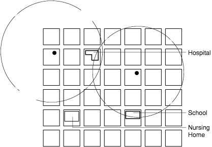
The county supervisor needs a list of hazardous waste sites whose 5-mile radius overlaps sensitive areas.

The sensitive_areas table contains several columns that describe the threatened institutions in addition to the zone column, which stores the institution ST_Polygon geometries:
CREATE TABLE sensitive_areas (id     integer,
                              name   varchar(128),
                              size   float,
                              type   varchar(10),
                              zone   ST_Polygon);
The hazardous_sites table stores the identity of the sites in the site_id and name columns. The actual geographic location of each site is stored in the location point column:
CREATE TABLE hazardous_sites (site_id   integer,
                              name      varchar(40),
                              location  ST_Point);
The sensitive_areas and hazardous_sites tables are joined by the ST_Overlaps() function. It returns t (TRUE) for all sensitive_areas rows whose zone polygons overlap the buffered 5-mile radius of the hazardous_sites location points:
SELECT hs.name hazardous_site, sa.name sensitive_area 
   FROM hazardous_sites hs, sensitive_areas sa
   WHERE ST_Overlaps(ST_Buffer(hs.location,(26400)),sa.zone);


hazardous_site  Landmark Industrial
sensitive_area  Johnson County Hospital

hazardous_site  Landmark Industrial
sensitive_area  Summerhill Elementary School
The following figure shows that the hospital and the school overlap the 5-mile radius of the county's two hazardous waste sites. The nursing home does not.
Figure 2: Using the ST_Overlaps() function

This graphic is described in the surrounding text.