The ST_Intersection() function takes
two ST_Geometry objects and returns the intersection set as an ST_Geometry
object. If the two objects do not intersect, the return value is an
empty geometry.
Syntax
ST_Intersection(g1 ST_Geometry, g2 ST_Geometry)
Usage
If an ST_LineString intersects an ST_Polygon, the ST_Intersection() function
returns the portion of the ST_LineString common to the interior and
boundary of the ST_Polygon as an ST_MultiLineString. The ST_MultiLineString
contains more than one ST_LineString if the source ST_LineString intersects
the ST_Polygon with two or more discontinuous segments.
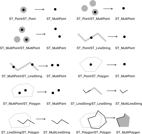
The following figure illustrates examples of the ST_Intersection() function. Figure 1: Intersection sets of geometries
Return type
ST_Geometry
Example
The fire
marshal must obtain the areas of the hospitals, schools, and nursing
homes that are intersected by the radius of a possible hazardous waste
contamination.
The sensitive areas are stored in
the sensitive_areas table that is created with the CREATE TABLE
statement that follows. The zone column, which is defined as
an ST_Polygon type, stores the outline of each of the sensitive areas:
CREATE TABLE sensitive_areas (id     integer,
                              name   varchar(128),
                              size   float,
                              type   varchar(10),
                              zone   ST_Polygon);
The hazardous sites are stored in the hazardous_sites table
that is created with the CREATE TABLE statement that
follows. The location column, which is defined as an
ST_Point type, stores a location that is the geographic
center of each hazardous site:
CREATE TABLE hazardous_sites (site_id   integer,
                              name      varchar(40),
                              location  ST_Point);
The ST_Buffer() function generates
a 5-mile buffer that surrounds the hazardous waste
site locations. The ST_Intersection()
function generates polygons from the intersection of the buffered
hazardous waste sites and the sensitive areas. The ST_Area() function
returns the intersection polygons' area, which is
summarized for all hazardous sites by the SUM operator.
The GROUP BY clause directs the query to aggregate the intersection
areas by hazardous waste site ID:
SELECT hs.site_id, SUM(ST_Area(ST_Intersection(sa.zone,
       ST_Buffer(hs.location,(5 * 5280)))::ST_MultiPolygon))
   FROM sensitive_areas sa, hazardous_sites hs
   GROUP BY hs.site_id;

    site_id          (sum)

        102 87000000.00000
         59 77158581.63280
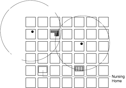
In the following
figure, the circles represent the 5-mile buffer polygons that surround
the hazardous waste sites. The intersection of these buffer polygons
with the sensitive area polygons produces three polygons:
the hospital in the upper left corner is intersected
twice, while the school in the lower right corner
is intersected only once. Figure 2: Using theST_Intersection() function
Have feedback?
Google Analytics is used to store comments and ratings. To provide a comment or rating for a topic, click Accept All Cookies or Allow All in Cookie Preferences in the footer of this page.