The ST_Intersects() function returns t (TRUE)
if the intersection of two geometries does not result in an empty
set; otherwise, returns f (FALSE).
Syntax
ST_Intersects (g1 ST_Geometry, g2 ST_Geometry)
Usage
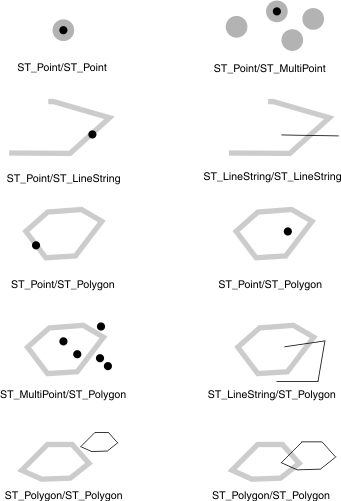
The
following figure shows various geometric objects that intersect.Figure 1: A selection of geometries
that intersect
The
results of the spatial relationship of the ST_Intersects() function
can be understood or verified by comparing the results with a pattern
matrix that represents the acceptable values for the DE-9IM. The ST_Intersects() function
returns TRUE if the conditions of any of the following pattern matrices
returns TRUE.
The ST_Intersects() function
returns TRUE if the interiors of both geometries intersect.
Table 1. Pattern matrix for the
ST_Intersects() function
The
table is a matrix. The top row and first column identify the geometry.
Interior (b)
Boundary (b)
Exterior (b)
Interior (a)
T
*
*
Boundary (a)
*
*
*
Exterior (a)
*
*
*
The ST_Intersects() function returns
TRUE if the boundary of the first geometry intersects the boundary
of the second geometry.
Interior (b)
Boundary (b)
Exterior (b)
Interior (a)
*
T
*
Boundary (a)
*
*
*
Exterior (a)
*
*
*
The ST_Intersects() function returns
TRUE if the boundary of the first geometry intersects the interior
of the second.
Interior (b)
Boundary (b)
Exterior (b)
Interior (a)
*
*
*
Boundary (a)
T
*
*
Exterior (a)
*
*
*
The ST_Intersects() function returns
TRUE if the boundaries of either geometry intersect.
Interior (b)
Boundary (b)
Exterior (b)
Interior (a)
*
*
*
Boundary (a)
*
T
*
Exterior (a)
*
*
*
Return type
BOOLEAN
Example
The fire marshal wants a list
of sensitive areas within a 5-mile radius of a hazardous waste site.
The
sensitive areas are stored in the following sensitive_areas table.
The zone column is defined as an ST_Polygon type and stores
the outline of the sensitive areas:
CREATE TABLE sensitive_areas (id     integer,
                              name   varchar(128),
                              size   float,
                              type   varchar(10),
                              zone   ST_Polygon);
The
hazardous sites are stored in the hazardous_sites table that
is created with the CREATE TABLE statement that follows. The location column,
which is defined as an ST_Point type, stores the geographic center
of each hazardous site:
CREATE TABLE hazardous_sites (site_id   integer,
                              name      varchar(40),
                              location  ST_Point);
The
query returns a list of sensitive-area and hazardous-site names for
sensitive areas that intersect the 5-mile buffer radius of the hazardous
sites:
SELECT sa.name, hs.name
   FROM sensitive_areas sa, hazardous_sites hs
   WHERE ST_Intersects(ST_Buffer(hs.location,(5 * 5280)),sa.zone);


name  Johnson County Hospital
name  W. H. Kleenare Chemical Repository

name  Johnson County Hospital
name  Landmark Industrial

name  Summerhill Elementary School
name  Landmark Industrial
Have feedback?
Google Analytics is used to store comments and ratings. To provide a comment or rating for a topic, click Accept All Cookies or Allow All in Cookie Preferences in the footer of this page.