Geographic coordinate system
A geographic coordinate system is a system that uses a three-dimensional spherical surface to determine locations on the Earth. Any location on Earth can be referenced by a point with longitude and latitude coordinates. The geographic coordinate system is appropriate for global data sets and applications, such as satellite imagery repositories.
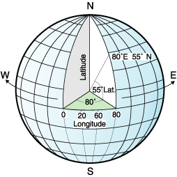
For example, the following illustration shows a geographic coordinate system where a location is represented by the coordinates longitude 80 degree east and latitude 55 degrees north.
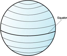
The lines that run east and west each have a constant latitude value and are called parallels. They are equidistant and parallel to one another, and form concentric circles around the Earth. The equator is the largest circle and divides the Earth in half. It is equal in distance from each of the poles, and the value of this latitude line is zero. Locations north of the equator have positive latitudes that range from 0 to +90 degrees, while locations south of the equator have negative latitudes that range from 0 to -90 degrees.
The following illustration shows latitude lines.
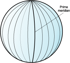
The lines that run north and south each have a constant longitude value and are called meridians. They form circles of the same size around the Earth, and intersect at the poles. The prime meridian is the line of longitude that defines the origin (zero degrees) for longitude coordinates. One of the most commonly used prime meridian locations is the line that passes through Greenwich, England. However, other longitude lines, such as those that pass through Bern, Bogota, and Paris, were also as the prime meridian. Locations east of the prime meridian up to its antipodal meridian (the continuation of the prime meridian on the other side of the globe) have positive longitudes that range from 0 to +180 degrees. Locations west of the prime meridian have negative longitudes that range from 0 to -180 degrees.
The following illustration shows longitude lines.
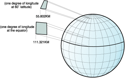
The latitude and longitude lines can cover the globe to form a grid, called a graticule. The point of origin of the graticule is (0,0), where the equator and the prime meridian intersect. The equator is the only place on the graticule where the linear distance corresponding to one degree latitude is approximately equal the distance corresponding to one degree longitude. Because the longitude lines converge at the poles, the distance between two meridians is different at every parallel. Therefore, as you move closer to the poles, the distance corresponding to one degree latitude is much greater than the distance corresponding to one degree longitude.
It is difficult to determine the lengths of the latitude lines using the graticule. The latitude lines are concentric circles that become smaller near the poles. They form a single point at the poles where the meridians begin. At the equator, one degree of longitude is approximately 111.321 kilometers, while at 60 degrees of latitude, one degree of longitude is only 55.802 km (this approximation is based on the Clarke 1866 spheroid). Therefore, because there is no uniform length of degrees of latitude and longitude, the distance between points cannot be measured accurately by using angular units of measure.
The following illustration shows the different dimensions between locations on the graticule.
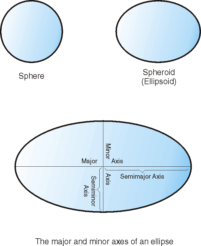
A coordinate system can be defined by either a sphere or a spheroid approximation of the Earth's shape. Because the Earth is not perfectly round, a spheroid can help maintain accuracy for a map, depending on the location on the Earth. A spheroid is an ellipsoid that is based on an ellipse, whereas a sphere is based on a circle.
The shape of the ellipse is determined by two radii. The longer radius is called the semimajor axis, and the shorter radius is called the semiminor axis. An ellipsoid is a three-dimensional shape that is formed by rotating an ellipse around one of its axes.
The following illustration shows the sphere and spheroid approximations of the Earth and the major and minor axes of an ellipse.
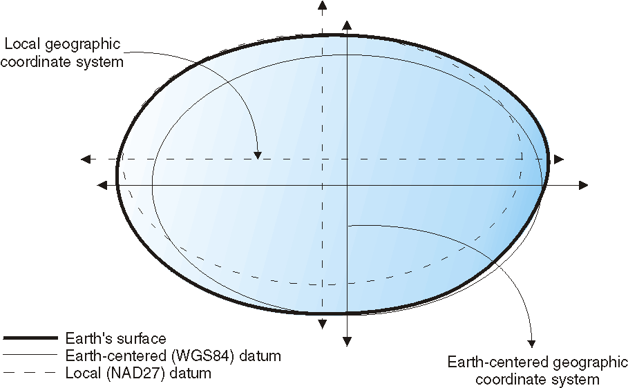
A datum is a set of values that defines the position of the spheroid relative to the center of the Earth. The datum provides a frame of reference for measuring locations and defines the origin and orientation of latitude and longitude lines. Some datums are global and intend to provide good average accuracy around the world. A local datum aligns its spheroid to closely fit the Earth's surface in a particular area. Therefore, the coordinate system's measurements are not accurate if they are used with an area other than the one that they were designed.
The following illustration shows how different datums align with the Earth's surface. The local datum, NAD27, more closely aligns with Earth's surface than the Earth-centered datum, WGS84, at this particular location.
Whenever you change the datum, the geographic coordinate system is altered and the coordinate values change. For example, the coordinates in DMS of a control point in Redlands, California using the North American Datum of 1983 (NAD 1983) are: "-117 12 57.75961 34 01 43.77884" The coordinates of the same point on the North American Datum of 1927 (NAD 1927) are: "-117 12 54.61539 34 01 43.72995".