HCL OneDB spatial solution architecture
You can create tables that contain HCL OneDB™ spatial data type columns. You can insert and store geographic features in the spatial columns.
For each spatial data type, there is a text file import and a text file export routine. Whenever you run a load or unload statement in the DB-Access utility, import and export routines are automatically called (the dbimport and dbexport utilities also use these routines).
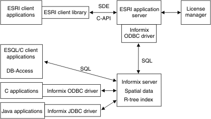
The ESRI ArcSDE service provides immediate access to the spatial data stored in your HCL OneDB database for the ESRI GIS software programs: ArcView GIS, MapObjects, and ArcInfo software. The ArcSDE service automatically converts spatial column data into ESRI shape representation, making it available to all ESRI-supported applications and other applications capable of reading this format. When you access spatially enabled tables through the ArcSDE service, you can write applications with the existing tools that are offered by ESRI GIS software or create applications with the SDE C application programming interface (API). An experienced open database connectivity (ODBC) programmer can also make calls to Spatial SQL functions.
- ESQL/C applications. Use the HCL OneDB Client Software Development Kit (Client SDK) to connect to the HCL OneDB server.
- C applications. Use the HCL OneDB ODBC Driver to connect to the HCL OneDB server.
- Java applications. Use the HCL OneDB JDBC Driver to connect to the HCL OneDB server.
Querying the spatial columns directly requires converting the data to one of the three supported external formats. The ST_AsText() function converts a spatial column value to the OGC Well-Known Text (WKT) representation. The ST_AsBinary() and SE_AsShape() functions convert the spatial column values to OGC Well-Known Binary (WKB) and ESRI shape formats, respectively. After the data is converted, applications can display or manipulate the data.
You use an R-tree index to allow indexing of spatial data. R-tree indexes are designed to provide fast, efficient access to spatial data.
- Sample spatial data
- ArcExplorer Java Edition, a lightweight visualization tool for spatial data. Enables the panning, zooming, and querying of colorful maps that are automatically generated from the data.