STS_GetLocNearest function
The STS_GetLocNearest function returns the nearest object to the specified point at the specified time.
Syntax
STS_GetLocNearest(
                    subtrack_name   VARCHAR(128),
                    begin_time      DATETIME YEAR TO FRACTION(5),
                    end_time        DATETIME YEAR TO FRACTION(5),
                    geometry        ST_Geometry)
returns ROW

STS_GetLocNearest(
                    subtrack_name   VARCHAR(128),
                    begin_time      DATETIME YEAR TO FRACTION(5),
                    end_time        DATETIME YEAR TO FRACTION(5),
                    geometry        ST_Geometry,
                    max_distance    FLOAT)
returns ROW

STS_GetLocNearest(
                    subtrack_name   VARCHAR(128),
                    begin_time      DATETIME YEAR TO FRACTION(5),
                    end_time        DATETIME YEAR TO FRACTION(5),
                    geometry        ST_Geometry,
                    max_distance    FLOAT,
                    uom             VARCHAR(128))
returns ROW

STS_GetLocNearest(
                    subtrack_name      VARCHAR(128),
                    begin_time         DATETIME YEAR TO FRACTION(5),
                    end_time           DATETIME YEAR TO FRACTION(5),
                    geometry           ST_Geometry,
                    max_distance       FLOAT,
                    uom                VARCHAR(128),
                    max_nearest_count  INTEGER)
returns ROW- subtrack_name
- The name of the subtrack table.
- begin_time
- The start of the time range. Can be NULL to indicate the first element in the time series.
- end_time
- The end of the time range. Can be NULL to indicate the last element in the time series.
- geometry
- The region of interest. Can be an ST_Point, ST_MultiPoint, ST_LineString, ST_MultiLineString, ST_Polygon, or ST_MultiPolygon. Must use the SRID 4326.
- max_distance (Optional)
- The distance from the geometry that defines the border of the region of interest. The unit of measure is specified by the uom parameter.
- uom (Optional)
- The unit of measure for the radius parameter. If unitOfMeasure is not specified, then it is meter for a geographic coordinate systems, and, it is the linear unit of measure for projected coordinate systems. If the projected coordinate system does not have a linear unit of measure specified, it is meter. Must be the name of a linear unit of measure from the unit_name column of the st_units_of_measure table.
- max_nearest_count (Optional)
- The maximum number of return values.
Usage
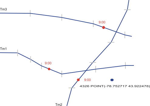
Run the STS_GetLocNearest function to find the set of objects, in order of distance from the geometry, at a specific time.
The following illustration shows three trajectories near the point (-78.752717 43.922478), with the trajectory of object m2 being the closest a 9:00, followed by the trajectories of m3 and m2.
Returns
The set of primary key values = The objects nearest the region, in order of distance from the region.
NULL = Nothing found.
Example: Return primary keys
The following statement returns which vehicle was closest to the specified region between the times of 2014-06-10 16:30:00 and 2014-06-10 17:00:00:
SELECT * FROM TABLE(STS_GetLocNearest('t_vehicle_subtrack',
         '2014-06-10 16:30:00', '2014-06-10 17:00:00',
         ST_Buffer('4326 POINT(-78.752717 43.922478)'::ST_Point,
                   1.00, 'kilometer'))::row(modid varchar(60)))
         AS t(mid);

mid  ROW('1001')

1 row(s) retrieved.
Vehicle 1001 was the closest vehicle.